The one thing missing from my book on medieval maps is medieval faces—the ordinary people who viewed and interacted with these extraordinary views of the world. That’s partly because I wanted to explore our interaction with the maps today and partly because we know so little about the people who “used” maps in the Middle Ages. There’s almost no direct evidence about people viewing these maps and their reactions to them.
But there is some indirect evidence. There are stories.
Today I want to tell a story about one medieval family and the Hereford Map. It involves a drowning, a belt, a wax image, and a miracle.
In 1287, a five-year-old girl named Joanna drowned in a pond outside the tavern her parents were visiting in Marden (a town north of Hereford). After she was dragged from the pond, her father, Adam, “measured” her to St. Thomas with his belt—meaning that he used his belt to measure her so that a wax image of her body could be made, and while he did so he called on the saint to heal his daughter.
This St. Thomas was Thomas of Cantilupe, a bishop of nearby Hereford Cathedral, who was in the process of being canonized because of his many miracles. While Adam measured his daughter, all the bystanders prayed. Later, Joanna miraculously revived. Thomas had healed her from afar.
The next day, Adam took Joanna to Hereford Cathedral, where “bells were rung, a procession held and the miracle ‘published.’”* A wax likeness of Joanna hung near St. Thomas’s tomb for many years before it finally fell apart (the first Madame Tussaud’s?).
Every year thereafter, Joanna and her parents made a pilgrimage, barefoot, to Hereford Cathedral, where they left an offering at St. Thomas’s tomb.
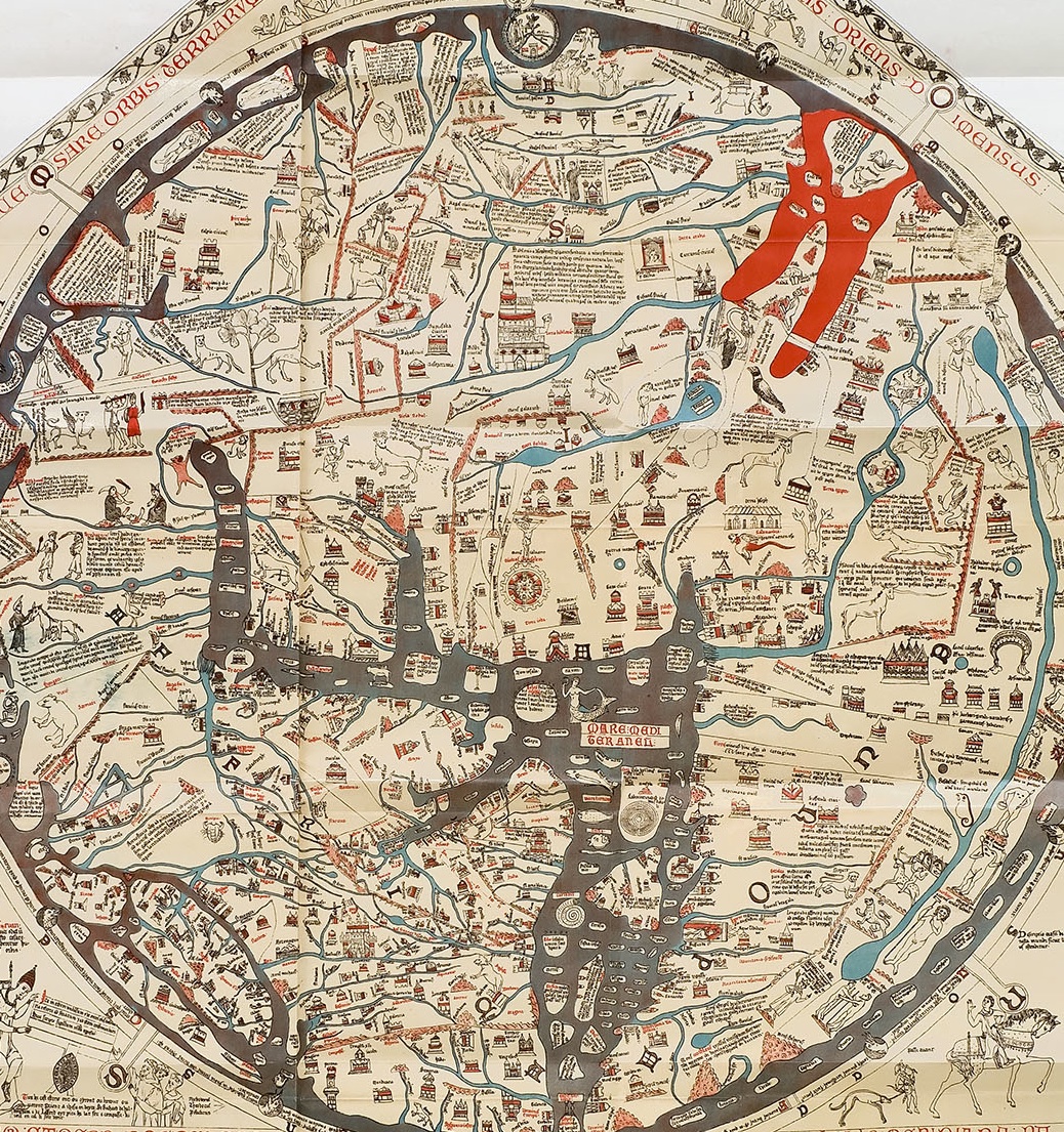
Several scholars believe that the Hereford Map hung right next to the tomb. (You can see a picture of how it might have looked in chapter 2 of my book.) When they visited St. Thomas’s tomb, Joanna’s family would almost certainly have seen the map. It was a key object that played a role in Joanna’s life – along with a belt, a tomb, and a wax image. It was part of this family’s yearly pilgrimage to the cathedral.
Exactly how they interacted with the map remains unknown. Maybe they reached out and, in honor of Joanna’s healing, touched the town of Hereford. (We know that many pilgrims did—in fact, they nearly wore the ink away!). Maybe they listened to a cleric talking about the map, like tourist guides do today. Maybe they gave thanks to Jesus, who centers the world shown on the map. Might they have knelt before the map, as before an altarpiece? We really don’t know.
But I like knowing their names. And I like knowing a little of their story. It reminds me that real people with real stories—real hurts, needs, and faith—saw the Hereford Map. It played a role in their journey of faith.
Like Joanna’s family, we are pilgrims, too. We journey with our own stories and needs. The Hereford Map, with its vision of Christ centering the earth, is a welcoming place to bring our faith (or doubt) and our need for healing. We can let it embrace us and draw us into its world. It is the very world we need—one centered on and transformed by the grace of Jesus Christ.
What story do you bring to the map and its Christ-centered world today?
*This amazing story, and others, is related in Diana Webb, Pilgrimage in Medieval England (London: Hambledon and London, 2000), pp. 74-75. Webb doesn’t discuss the Hereford Map in relation to these pilgrimage visits.